Tag Archives: Ozone Cafe

Leg 32 – to Scourie

The journey South begins.

01 June 2013

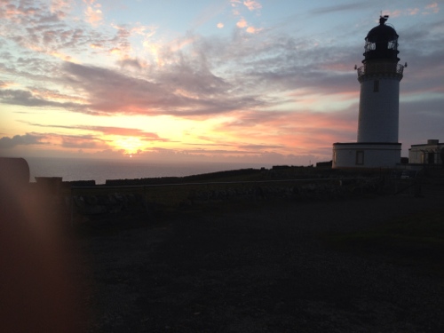
I had one of the best nights sleep of the tour so far at Cape Wrath, whether that be down to the peaceful location or really spongy grass I had as a mattress I’m not sure, probably a combination of both. I’d got up once to photograph the lighthouse in operation; no shipwrecks to report so looks like it was working. There were still deer around, grazing on the lush grass around the lighthouse.

Cape Wrath lighthouse

Cape Wrath lighthouse by night


Steep cliffs!

Steep cliffs next Lighthouse

I was up early as I wanted to make sure I made the 09.30 ferry, although I suspected it might be a bit later today because of  the tides. Not wanting to risk it I was packed up and on the road/bumpy track by 7.30, allowing enough time to deal with any punctures picked up en-route. This was after settling up with John and buying one of the Ozone Cafe/Cape Wrath t-shirts – my first sourvenir of the tour. Big thanks to John and the Ozone Cafe for the excellent hospitality and very tasty salmon dinner, and look forward to a return visit some day. Also bid adieu to the enthusiastic Spirnger Spaniel patrol.


Leaving Cape Wrath

Leaving Cape Wrath

I rode back down the track to the ferry contemplating what it must be like living a the Cape permanently. Reckon it must be a hard life but rewarding. There’s no mains electricity or water, no mobile reception, although there is a landline. Despite the lack thereof I can see the attractiveness of being cut off from all the crap the rest of us encounter via the media etc, living slightly more on the edge, but in a beautiful spot.

Passing the track down to the bothy I hoped Iain and Angus had had a good night too, and had a safe kayak today – http://www.coldwetwater.blogspot.co.uk Good luck around the rest of the Scottish coast.

Back through moorland to the ferry

Back through moorland to the ferry 


Bridge over rocky stream

Bridge over rocky stream 


Wild landscape around the Cape
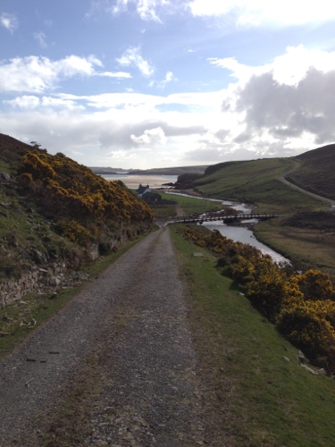
Wild landscape around the Cape 


One of the better road sections down to a farmstead

One of the better road sections down to a farmstead


Panoramic view of sandy kyle

Panoramic view of sandy kyle


I made it in good time back to the slipway to wait for the ferry, without any punctures, but with three completely loose spokes I had to tighten. The combination of a bumpy road, heavy bike, and a back wheel not really built for a touring bike had obviously take its toll, and was something I was going to have to keep an eye on. I was very glad I’d packed a spoke tightener, but will have to be careful not to over-tighten.

Whilst waiting I had a second breakfast of flapjack and contemplated putting a brew on, but then saw the ferryman arrive on the other side of the kyle and start loading today’s visitors into his boat. The ferry duly arrived bringing a full minibus load, and several cyclists on three separate trips, so John was in for a busy day at the Ozone Cafe. I bid good morning to everyone, extolling the virtues of the Cape, before they trundled off and I lifted my panniers and bike on-board the boat, the only passenger heading back this morning. 

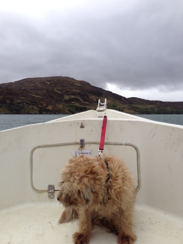
I chatted to John the ferryman on the trip across, who said the tide was only just high enough to allow easy access to the pier for my bike on the other side. I was glad I wasn’t going to have to wade ashore! John ferries visitors back and forth most days, with his dog on the prow. The weather can change very quickly around Durness, and if it looks like it could turn John either won’t run the ferry, or gives people fair warning that they might get stuck on the Cape. It’s happened a few times – people cross at their own risk and sometimes get stuck there for the night. John confirmed that there are Golden Eagles in the area, but I hadn’t seen any unfortunately. 

Bidding the Cape a final goodbye, I reattached my panniers and cycled off down the A838, travelling south for the first time on the mainland in ages, which felt a bit strange. Of course I had a headwind, but it was fairly mild, and I was soon distracted by a long hill climb. It felt like quite a long stretch to Rhiconich, past the odd loch, and between mountains. 

Road to Rhiconich - fairly bleak landscape

Road to Rhiconich – fairly bleak landscape


Road to Rhiconich - mountains abounding

Road to Rhiconich – mountains abounding


There were some handy public toilets in Rhiconich, which came as a welcome relief – they’re right next to a rather remote and lonely looking police station. Post toilet break I turned right, wanting to head up towards Sandwood Bay a bit, although I didn’t think I’d make it all the way up there – it’s a dead end and I wasn’t sure about the state of the roads/tracks anyway.

I rode up the road alongside Loch Inchard to Kinlochbervie, passing through villages with names I had trouble pronouncing such as Achriesgill and Inshegra, although Badcall was easier. Most of the information notices, signs and town names are in Gaelic as well as English. I haven’t heard any Gaelic spoken yet but I’m sure some locals mix in a bit with some of their sentences to confuse me sometimes. 

Narrow entrance to Kinlochbervie harbour

Narrow entrance to Kinlochbervie harbour


Kinlochbervie harbour

Kinlochbervie harbour

Kinlochbervie is a small town built up around the harbour which has an active fishing community by the looks of it. I’d passed what looked like a few salmon farms on the way up the loch, at least I think that’s what they were. Could be wrong as they might have just been channel markers in this instance. A largish fishing boat was just returning to port with its catch, which was duly unloaded and packed in ice. I was passed a bit later by fairly fishy lorries transporting the catch off elsewhere, no doubt to restaurants and factories.

I had lunch at the hotel in Kinlochbervie, wanting to get out of the weather for a bit which was turning showery and windier. Great cheeseburger and chips, followed by a chocolate brownie sundae just to keep the carbs topped up. Taking advantage of the free wifi I also had a quick FaceTime call with my Dad which was nice. Mum was out somewhere but I’d no doubt catch up with her later.

Shoreline in Kinlochbervie

Shoreline in Kinlochbervie


Fishing farms or channel markers?

Fishing farms or channel markers? Or nets? Thinking channel markers.


Clouds closing in still

Clouds closing in still

Post an email catchup the weather had improved somewhat, so I hit the road again continuing up towards Sandwood Bay. I made it as far as Oldshoremore, before turning around and heading back down the loch to rejoin the main road south. There were a couple of quite significant hill climbs, so I was glad I’d consumed the chocolate brownie sundae, although I was getting irritated by the headwind as I pedalled towards Scourie, my destination for the evening.

I passed through some nice countryside, occasionally shouting at the still persistent headwind which was making hill climbs twice as hard. Shouting didn’t stop the headwind but it made me feel better, and there was no-one else around to alarm, just the odd startled sheep and deer. There might have been the occasional haggis too but they were staying well hidden.

Road to Scourie

Road to Scourie

I passed through Laxford Bridge, and then turned left on another detour around a minor road circuit that would take me past Handa Island. I’m not sure what possessed me to add on the extra miles, when my legs were already tired. I had a feeling it was going to be fairy flat, I was wrong.
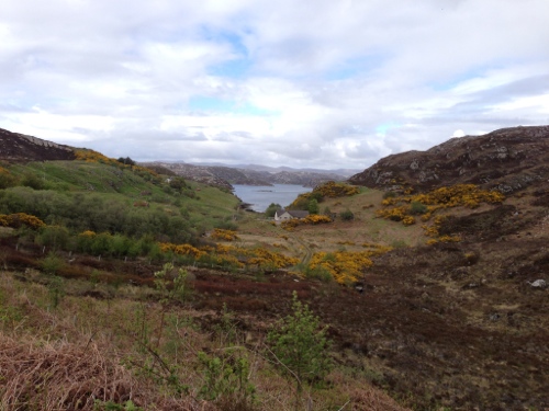
Tarbet detour 1

Tarbet detour 1


Tarbet detour 2

Tarbet detour 2


Tarbet detour - loch which I thought I recognised from a film

Tarbet detour – loch which I thought I recognised from a film with Vikings in, chasing Arthur and his Slavic Knights – King Arthur with Clive Owen, but there are lots of lochs like this about in this neck of the woods


To begin with there was a sign warning about ‘the bull’, but I didn’t encounter any aggressive bovines. I spent quite a bit of time wondering what I’d do if I did encounter a bull and it decided to chase me. I did have red panniers after all, and previously bullocks had got quite excited when I cycled past them in fields. I decided the best course of action if I couldn’t out-pedal it would be to abandon the bike to its rage and climb up a tree or boulder. I cycled down the narrow undulating road through Foindle, and Fanagmore, then around to Tarbet. There were some pretty steep climbs and descents which got me huffing and puffing a bit. 

I stopped in Tarbet and had a look at Handa Island, which is one of Northern Europe’s biggest seabird colonies, home to Gannets, Razorbills, Skuas, Fulmers and all sorts of other birds. Porpoises, Orcas and seals are also seen in the area, along with other whales and basking sharks from time to time. The ferry to Handa Island wasn’t running today, and I didn’t see a lot aside from a large bird of prey quite high up, which might have been a golden eagle, or maybe just a buzzard. It definitely wasn’t a pigeon.

Handa Island

Handa Island


There’s a seafood restaurant in Tarbet, the Shoreside Inn, that looks like it’s worth a visit, but I decided to press on to Scourie. The whole circuit is worth a ride if you’re up for a challenge, even though it’s effectively a dead end. The road is narrow, undulating, with steep sections you can whizz down and get most of the way up the following hill. I was lucky as I didn’t meet any traffic, but I imagine it can get busier when the ferry is running and it’s the holiday season. There’s a massive 15% hill out of Tarbet which got me going again, even if my chain did slip a couple of times and one of brake blocks slid out when I stopped; the grub screw holding the pad in had fallen out, but luckily I found the pad and slid it back in, okay as long as I don’t slide backwards with the brakes on. I’ll have to temp fix the brake pad until I can find a new screw, which could be a while considering the lack of bike shops around here.

I made it back to the main road, again not encountering feisty bovines, and turned right to Scourie straight back into the headwind which was really starting to p*ss me off now. It was a slow last couple of miles to the campsite, bringing today’s total to 52; it felt like more. Having arrived I had a pint at the on site bar to recuperate before pitching my tent in a nice spot right next to the sea. The campsite is situated in a great spot, laid out in tiers with lots of room, great facilities, and the on-site bar and cafeteria which are a nice addition – lots of locals in the bar too so must be alright!

Scourie campsite

Scourie campsite


After a hard day I really just wanted to eat some food and collapse, but I noticed two more loose spokes on the back wheel, the Mavic. One of the nipples had also disappeared inside the rim, so I spent the next 30 minutes taking the tyre off, finding the nipple, reattaching it to the spoke, then putting the whole thing back together again and back on the bike and pumping up the tyre. I could see this was something I was going to have to regularly check.

Feeling very grimy post the ride and bike fix I grabbed a shower before heading in search of food, and free wifi with any luck. I ended up at the as Scourie Fisher Hotel which had the food, but not the wifi which was only available to residents unfortunately; seems a bit silly seeing as I would have stayed there longer if it had been open to touring cyclists. Still the haggis was nice, as was the fried chicken, and good ale.

Feeling tired and irritable I decided to have an early night, post writing up my journal. I had a check of my maps before turning in; there was still a lot of Scotland left, and that was without including the Hebs, Skye and Mull, which I wanted to visit if time allowed.

Dusk at Scourie campsite

Dusk at Scourie campsite

Leg 31 – to Cape Wrath

A short but bumpy ride…

31 May 2013

I woke up with my fingers crossed that the fog had disappeared overnight, it had, although it was still overcast and cold with a moderate south westerly bringing with it rain. I showered and had a shave, wanted to look my best for the Cape, then had breakfast of cheese and pitta bread, before packing up. I had to shake off my tent quite a bit which had gotten wet due to overnight rain. I stood there with it billowing around me as the German bikers roared off somewhere, I must have looked a bit strange but my tent was mostly dry after the vigorous shaking.

Beach next to Durness campsite - another grey day at present

Beach next to Durness campsite – another grey day at present


I had seen a sign that said the ferry ran from 11.00 each day, so I aimed to get there in plenty of time to ensure I didn’t miss it. I pedalled from the campsite through Durness, to the Balnakeil Craft Village, before taking an old track back to the main road. It was marked as a road on the map, but wasn’t really, turning mostly into a field full of sheep at one point who weren’t entirely pleased with my intrusion.

Post extricating myself from the field and its malcontent occupants I rode down the hill to the ferry slipway; I was going to say ferry terminal but it was nothing so grandiose. Unfortunately the sign there said the next sailing was at 13.00, the first having been at 09.30, d’oh. I made a mental note not to trust information notices again. 

East Kiodale Pier - no ferry in sight

East Keodale Pier – no ferry in sight


So I rode back up to the Balnakeil Craft Village where I’d seen a promising cafe earlier – the Cocoa Mountain Cafe. Getting out of the rain for a bit was a welcome relief, and my spirits were further bolstered by one of the cafe’s Mountain Mochas (decaf in this instance). The mocha did not disappoint being one of the chocolatiest things I’ve ever drunk, but balanced by the coffee so it wasn’t too sickly. They make their own chocolates too but I abstained, being a bit chocolated out after the drink.

Cocoa Mountain Cafe - Mountain Mocha

Cocoa Mountain Cafe – Mountain Mocha


I spent a bit of time at the cafe chatting and writing up my blog, before cycling back through Durness to meet the ferry at 13.00. I use the term ferry here quite loosely, it’s a motor boat with enough room to accommodate about 8 people, plus the ferryman John and his dog. It’s perfectly adequate for getting people across to the minibus waiting on the other side of the narrow kyle, and has enough room to fit bikes in too. It cost me £8.00 for me and my bike. If you’re taking the minibus too it’s another £10.00, so I was glad I had alternative means of transport.

The East Keodale Pier

The East Keodale Pier – and some nice flowers


The Ferry Boat Dog

The Ferry Boat Dog, en-route across the kyle


On my way over with fellow passengers and another dog

On my way over with fellow passengers and another dog


The other side of the kyle

The other side of the kyle


I was slightly worried the dogs might have a disagreement but the voyage passed peacefully, and I had a chat with my fellow passengers – thanks for helping with my panniers, and for the encouragement!

Having disembarked I loaded everything back on to my bike I set off on the circa 11.5 mile ride to the Cape Wrath lighthouse and Ozone Cafe. I quickly lost sight of the minibus as it steamed off ahead, but didn’t envy the passengers with it bumping around all over the place; they needed padded shorts like mine for the journey! 

Entering the MOD firing range

Entering the MOD firing range


The road is in a pretty poor state but passable on my bike. There are quite a few hills so was hard going when you throw in the bumps too. I didn’t want to go too fast for fear of damaging my wheels or tyres. I passed several cyclists going the other way back to the ferry, who’d got the 09.30 boat. One of them had a puncture which he was mending – he was on lightweight continental tyres so not that surprising on the puncture front. I also passed through the MOD firing range, thankfully no naval bombardments were going on today, although it would have made for a more interesting blog chapter.

The road passes through moorland for the most part, with bridges crossing the occasional stream, a few herds of sheep and the occasional farmstead. Not many if any trees up here – probably too exposed, or they get eaten by the deer.

Road through moorland to Cape Wrath

Road through moorland to Cape Wrath


Looking back down the kyle

Looking back down the kyle


Exiting the firing range

Exiting the firing range


Lighthouse finally in sight

Lighthouse finally in sight


I finally made it to the lighthouse and Ozone Cafe after about an hour and 45 minutes’s ride. The minibus was still there having not set off on its return leg yet, so I said hi to a few people before it left. I met John who runs the Ozone Cafe, who pointed me in the best direction of somewhere to pitch my tent, down next to the high stone wall where I’d be sheltered from the wind. I pitched my tent then went back to the cafe for a cold beer, a welcome beverage after quite a tricky ride; it’s quite mentally tiring to be constantly on the look out for potentially wheel damaging or cyclist injury obstacles on the potholed road. John told me the council patch it up every summer but it’s getting worse, eroded by the harsh weather especially in the winter, not to mention the frequent minibus tours – must play havoc with the van suspension. John also said he could supply dinner for me which I quickly agreed to – salmon being a better option than pasta.

Tent set up in the lea of the wall

Tent set up in the lea of the wall


Two walkers arrived whilst I was enjoying a beer at the cafe, having trekked up from the bothy a few miles away. It turned out they had kayaked around from Sandwood Bay this morning, and were staying the night at the bothy. Iain, the older of the two, is attempting to kayak around the whole Scottish coastline, no mean feat, and had been joined by his son Angus for the week. As with me, but probably more so, they’re really effected by the wind, as well as the tides and currents, so it can be slow going some days and really quick others. Pretty extreme kayaking around the coast of scotland – I’ve seen how quickly the  tide can rip through some of the narrow channels, and the weather can change pretty quickly. Iain said the maximum he’s  travelled in one day is about 50km, pretty impressive in my book. You can check out his blog at http://www.coldwetwater.blogpost.co.uk

I spent a while chatting with them over a beer, good to swap stories. They’d kayaked into a few of the sea caves down below the cape, which you can only get to from the water, sounded amazing. It must be a completely different perspective from sea level. The sea bird colonies are also a lot more visible from down there; they’d seen hundreds of gannets – I still really want to see them fishing. Iain and Angus (McBride) left after an hour or so leaving me pretty much alone to walk around the cape and take a few photos, which I’ll include at the end of this post.

The area around the lighthouse is wonderful, a harsh environment to live in when the weather is bad, but beautiful on evenings such as this, with moorland, sheer cliffs, seabirds and grazing deer. On other days you might have seen a whale or dolphins off the coast, but I didn’t spot any today. I think this was the furthest point from home I’d get to on the UK mainland, but will have to check that, it certainly felt like the most remote.

The tranquility was at one point shattered by the barking of a pack of dogs, and a group of five enthusiastic springer spaniels careered around the corner of the lighthouse buildings to come and see me. They turned out to be search and rescue dogs that John keeps, and once having found me the barking stopped, with a few wet noses checking me out. They bark because that’s what they’re trained to do when they find someone, but they were very friendly.

I retreated to my tent for a bit and promptly feel asleep it was so peaceful, waking up about 18.00 in time for dinner. I popped back up to the cafe and dined on wild Atlantic salmon, with new potatoes, peas and carrots, with butter. Absolutely delicious. I chatted with John for a bit, who’d caught the salmon himself, it was much nicer than the farmed stuff which he is fairly critical of, the fish being full of chemicals. In the past he’s worked on a salmon farm, and talked to divers who’ve been underneath the salmon enclosures where there are piles of waste which nothing touches, sounds horrible. 

John confirmed it can get pretty fierce up here in the storms and high winds, but it’s a stunning spot, with shipping slowly cruising past on the horizon. Apparently you get naval ships moored up close by during exercises, and they often leave John some of their supplies at the end of their stay in the area. He’s kept busy all the time with maintenance and looking after visitors. The Ozone Cafe is effectively open 24 hours a day, all year, to cater for anyone that might turn up at any time. Hikers can arrive at any time of the night completing the Cape Wrath trail. John has been here 5 years, with visitor numbers gradually increasing. I hope more people visit but not too many as to spoil the feel of the place – I don’t think that will happen given its remote location.

The lighthouse, built by Robert Stevenson again, was constructed in 1826 post great demand after 3 ships were lost in one night alone on the treacherous coastline. The Stevensons built a total of 96 lighthouses around the coast of Scotland, a pretty amazing legacy, and also advised and built similar structures abroad, as far away as New Zealand and Japan.

A lighthouse is certainly needed at Cape Wrath, even though it’s unmanned now as so many are. John says he has to go and reboot the lighthouse computer for the Lighthouse Service frequently as it crashes, so sounds like it would benefit from a keeper still! It’s a shame there are less lighthouse keeps now. They provided a valuable service to the coastguard, keeping an eye out for people in trouble, and providing real time weather reports which were also invaluable. They also used to record details of the wildlife in the area, providing great information to naturalists. Unfortunately some of the lighthouse out buildings are in a bit of a state of poor repair now with no one around to upkeep them.

Cape Wrath is a apt name haven the location and weather that can hit the area. The name actually originates from the Norse words for turning point (area called Am Parth in Norse I think) as this is where the Norse ships turned East to go back home on their trading or being a Viking voyages.

The Ozone Cafe and Cape get quite a few visitors, either people who’ve come over on the ferry and minibus, hikers doing the Cape Wrath trail, or kayakers! It’s a must visit spot if you’re in the area, and had been on my list from day one so I was very glad to have made it, and that it wasn’t foggy. I felt quite exhilarated by the whole experience, and certainly slept well that night. If you’re cycling the road across to the lighthouse you’ll definitely need padded shorts though! Be warned there are no toilets at the moment, fine for me but could be tricky for some.

There was a cool poem on the wall of the cafe that I thought I’d include, written by Sir Walter Scott, one time commissioner of the Northern Lighthouses, in 1814.

Far in the bosom of the deep

O’er these wild shelves my wrath I keep

A ruddy gem of changeful light

Bound on the dusky brow of Night,

The Seaman bids my lustre hail,

And scorns to strike his timorous sail.

Cape Wrath Lighthouse and Ozone Cafe

Cape Wrath Lighthouse and Ozone Cafe

The Lighthouse

The Lighthouse


Cape Wrath foghorn

Cape Wrath foghorn

View from hilltop down to Lighthouse

View from hilltop down to Lighthouse

Another lighthouse shot

Another lighthouse shot

Cape Wrath - dramatic cliffs

Cape Wrath – dramatic cliffs

Cape Wrath - dramatic coastline

Cape Wrath – dramatic coastline

Cape Wrath - sun going down

Cape Wrath – sun going down

Cape Wrath - Red Deer coming joint me for the evening

Cape Wrath – Red Deer coming joint me for the evening

Cape Wrath - Swallow or House Martin?

Cape Wrath – Swallow or House Martin?

Cape Wrath - Deer silhoutetted

Cape Wrath – Deer silhouetted 

Cape Wrath - Sunset

Cape Wrath – Sunset

Cape Wrath - Sunset 2

Cape Wrath – Sunset 2

Cape Wrath - Lighthouse on

Cape Wrath – Lighthouse on

Cape Wrath - Spring spaniel patrol

Cape Wrath – Spring spaniel patrol

Ozone Cafe - wild salmon dinner

Ozone Cafe – wild salmon dinner

The Ozone Cafe

The Ozone Cafe

Too many pictures!

Too many pictures