
13 July 2013
My tent turning into an oven pretty early on indicated it was going to be another hot day, so I rolled out before it got too unbearable at about 07.30. The campsite was already very active with people getting ready for the Goodwood Festival of Speed. I could hear bacon sizzling from all directions; the smell was very attractive.

Loveders Farm campsite – morning campers
Ian of course hadn’t had the ‘benefit’ of a tent, and certainly hadn’t needed one. I was quite jealous of his sleeping mat which, as opposed to mine, appeared to stay inflated throughout the night. Mine hadn’t really done that since Lincolnshire but I’d just got used to it. I might have to invest in a similar one if I can remember the make (Ian?).
In the daylight you could see just how busy the campsite was with punters going to the Festival of Speed; there was an air of excitement and I almost wished we were going that way, but the traffic would have been horrendous.
Ian soon emerged from his cocoon like bivvy bag, and we set about getting ready for the day ahead. Although we didn’t have bacon we did have lots of cheese and pickle, and chocolate milk, and fruit, so hearty fare was had, with more sandwiches prepared for lunch. After a shower we packed up and got on the road for about 10.00, cycling from Nutbourne down to Bosham, an ancient village with references back to Roman Times.

Bosham 1
Emperer Vespasion may have built a house in Bosham; the Romans certainly built a basilica there. Fishbourne is just up the road where there’s a famous Roman villa. King Canute also had a palace in the village, and his daughter allegedly drowned in the mill pond and was buried in the church yard. Canute was the monarch who commanded, unsuccessfully, for the tide to stop coming in, to show his sycophantic court that there were limits to his power. This seems like a bit of a risk to take as a medieval king if you ask me; I’d prefer them to think me all powerful to discourage assassination attempts. King Harold, who was killed at the battle of Hastings, might also have been buried in the church; it’s all rather speculative.

Bosham 2
The road around the inlet at Bosham is very low, and floods regularly at low tide, however we were in luck as the tide was out as we pedalled around it. Actually it would have been more fun if the tide had been in a bit, as Ian and I have a tendency to do stupid things when we get together, or at least he entices me into doing stupid things; there could well have been some stunts had the road been waterlogged.

Bosham 3 – a rare photo of me on my bike
We continued around the coast and up to Fishbourne, using a cycle path to get most of the way to Chichester. The roads were getting increasingly busier as I rode further east, and the cars more expensive looking. This seemed to directly correlate to a reduction in driver patience and road etiquette, so I was glad to be off the road even for a short while. We rode past the Roman villa/palace at Fishbourne and down into Chichester, where we stopped for a break in a cafe; I had an excellent pineapple and mango smoothie, and was seriously tempted with the fry up they had on offer.

Cafe stop in Chichester
Chichester grew to importance in Roman times, and its street plan still resembles the layout of that original town, with a Roman road going up to London, and another going to Silchester. It continued to be an important city through the centuries; King Alfred the Great fortified it during his battles against the Danes.
That’s probably enough on the Time Team front; back to the cycling. Refreshed we took the B2266 down to Bognor Regis, after a great stretch alongside a canal. It was lovely riding away from the traffic again, although that didn’t last once we rejoined the road. The holiday season was definitely in full sway along the coast, with a group of oldsters singing Vera Lynn numbers, and various acts along the seafront.

Fundraisers in Bognor – knocking out a few Vera Lynn numbers

Belly dancers on the beach
We passed cheerleaders as well, always a bonus! And there was a Birdman competition scheduled for later in the day but we had to get on. Birdman competitions are a little odd, but great fun to watch. Contestants in various costumes and contraptions launch themselves off a pier, trying to ‘fly’ the furthest distance possible before crashing into the sea. Google images will supply pictorial evidence in this case, should you require it.

Beautiful day along the South Coast
We continued along the coast to Littlehampton, stopping to consume sandwiches and the occasional icecream to take the edge off the hot day, and to maintain energy levels. It was a nice change to ride with someone else, and we were pretty equally matched speed wise. I’d been worried Ian would be a lot faster than me with his lighter bike, compared to my Ridgeback with its bulging panniers, however he had much fatter tyres which thankfully slowed him up a bit, and I was more used to hills by this stage.

Me riding down the A259 – not a great road for a cyclist
We made it to Littlehampton and obtained directions from some other cyclists as to the best route to Worthing, trying to avoid the busy main road as much as possible. Maybe it was the heat however drivers were definitely being more aggressive in the South East, or maybe it was because there were two of us; shouldn’t have made any difference as we were in single file. I’m sorry to say that I’ve just come to the conclusion that whilst you can’t generalise, there are just a higher percentage of impatient, irritable and bad drivers in the South East, compared to the rest of the country, barring large cities where maniacal driving is something of the norm. I grew up near Hastings and Eastbourne so I already had a pretty good inkling that this was going to be the case. Thankfully there are quite a lot of quieter roads and cycle paths you can use, and the countryside is lovely to ride through.

Worthing Pier
Just before Worthing I spotted a bike shop, somewhere between Ferring and Goring-by-Sea. My old cycling gloves were in the process of disintegrating having taken a battering over the last few months, in all weathers, and after having been soaked with sweat and at times blood from various nicks and scratches. One glove had lost two gel pads, and the other was in danger of losing the same ones, so it was time to replace them; they really help my hands stop developing pins and needles after a few hours riding. I opted for Endura fingerless gloves again, but a slightly different type to my current ones. The new gloves were far less smelly, and very comfy; I instructed the helpful shop staff to treat my old ones as a biohazard and burn them at the first opportunity. We’d been drinking a lot of water throughout the day and the shop also let us refill our waterbottles, which was much appreciated; think the shop was http://www.southdownsbikes.com , so check them out if you’re in the area.

Ian’s bike – he was travelling light
We pedalled on, battling through traffic and the occassional swearing driver to Worthing, and then on to Shoreham-by-Sea which was packed with people enjoying the sunshine. There were lots of beach huts along the Shoreham seafront, some of which were immaculately finished, with extravagant interiors. People obviously go to a lot of effort to kit them out and maintain them; they’re not something I’ve ever considered owning but I can see the attraction if you live near a nice beach, and they’d be ideal for storing your windsurfing kit in, if it weren’t for security worries.
We had to double back in Shoreham because the cycle bridge over the lagoon hadn’t been finished yet, despite the cycle route signs pointing us in that direction. I’d hoped we’d be able to meet up with Anthony Sheehan in Shoreham, who’d been following my travels via Twitter, however after the traffic and frequent icecream stops we arrived a little too late. Hope you had a good day’s ride anyway Anthony, and cheers for the messages.
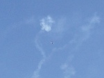
Riding on down the A259 we arrived in Hove and then Brighton, where we stopped to meet up with Ian’s sister Caroline, who I hadn’t seen in ages, her husband Roger and their 6 month old baby Jasmine. It was great to sit on the grass in the sunshine down by the seafront, which was packed with likeminded individuals having picnics, the odd drink, or quite a lot of odd drinks in some cases. We were also treated to some bonus food courtesy of Caroline and Roger – couscous and quinoa, very tasty and good carb loading stuff. We spent about an hour lazing before deciding we really ought to head on towards the South Downs and find somewhere to camp for the night, however it had been very pleasant relaxing for a bit, and watching a plane do some aerobatics over the beach.
-
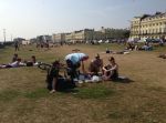
- Brighton Seafront – meeting up with Caroline, Roger and Jasmine
-
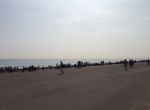
- Brighton Beach
-
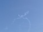
- Aerobatics 1
-

- Aerobatics 2
-

- Aerobatics 3
-
- Aerobatics 4
-
- Aerobatics 5
-
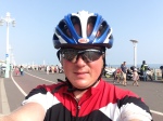
- Me on Brighton seafront
Thanks for the encouragment and mention on your website Caroline and Roger – http://www.dragonflyclinic.com – sports therapist and other treatments plus pilates if you’re in need. Hope to see you again soon; think Ian, Chris and I might be passing through Brighton sometime early next year if a plan comes to fruition.
Energy levels replenished we picked our way along the cycle path that runs down Brighton seafront, dodging the multitude of tourists and locals strolling about in the sunshine, who frequently meandered into the cycle lane. It was absolutely packed with people, especially around the pier. I guess folk descend from London and its boroughs for the weekend, especially if the weather is good.
So it was slow going getting out of Brighton, but we eventually made it passing the marina and heading for the hills as the South Downs rose up before us. These were the first serious hills we’d encountered all day, and with the heat Ian was struggling slightly as we passed through Rottingdean, Peacehaven, and on to Newhaven. I’d probably underestimated how acclimatised I was to riding long distances in hot weather, compared with my cycling buddy for the weekend, and despite drinking lots of water he realised later he may have suffered from a touch of heatstroke. We stopped in Newhaven and nipped into the supermarket to grab some supplies; it was nice to stand in the freezer isle for a bit again.
After a couple of pints of banana milk we both felt a lot better, and rode on to Seaford and ‘up’ into the ‘Downs’, which seems a little contradictory but there you go, that’s the English language for you.

Coast off Seaford
The scenery around the Cuckmere Haven and the Seven Sisters country park took me back to my childhood when I’d come here on Geography field trips to study the Oxbow lakes, or to visit the nature centre and walk with my brother and parents; we acquired some stick insects which were pretty fascinating at the time. There followed a monster climb up to Friston Forest, as we ingored ‘Route 2’ which directed us inland towards Polegate, sticking instead to the coast road (A259 still).
We were in familiar territory as we sped down the hill to East Dean, heading for the Tiger Inn where dinner and a cold pint awaited.

Bikes resting in East Dean after a hot days ride
Having grown up near here I knew of several good pubs, however the Tiger was reliable and with the South Downs on our doorstep there’d be loads of places to crash out later.

The Tiger – East Dean
It was busy but we managed to squeeze on to a table outside, and ordered a couple of pints of Harvey’s Ale and the pub’s homemade burgers for dinner. Harvey’s Brewery is based in Lewis, just down the road; unfortunately I’m not related as far as I know, but the beer is very good, matching anything brewed in Norfolk aside from perhaps Nelson’s Revenge. We spent a very pleasant few hours in the pub ‘rehydrating’ as the sunshine disappeared, to be replaced by a balmy evening with clear skies. A large group of cycle tourers appeared later on for dinner, and then rode off towards the beach; I wasn’t sure where they were going to camp but we’d decided back up the hill was probably the best bet.

Tiger Inn – busy evening
Having eaten and drunk our fill we left the pub and headed back up towards the forest and top of the hill, pushing our bikes through a meadow above East Dean.

Tiger Inn sign
No tent was required, not that Ian had one, so we both just lay down in the long grass on our sleeping mats, watching the stars and odd sattelite travelling across the night sky. It was a great spot to sleep for the night, and whilst not strictly legal we weren’t bothering anyone, or wrecking the joint, and you wouldn’t know we’d been there by the time we left in the morning. I think it was probably National Trust land and we’d be gone early, so probably wouldn’t be noticed by anyone aside from the odd dog walker. I just hoped there weren’t any cows or sheep in the meadow that might come and try and get friendly with us later on in the night; knowing my luck it would sheep, infernal creations.
We’d covered 65 miles today, which was an excellent effort from Ian considering the heat and the fact that whilst he’s done lots of long mountain bike rides before, he’s not really done much in the way of cycle touring. We’d only have a short ride tomorrow to get over towards Hastings, where I was going to stop for the night with my parents and Ian lived anyway.
It was great falling asleep under a spectacular starry sky, and waking up to a wonderful view as the sun rose.

Sunrise on the South Downs


